History of london boroughs: origins and evolution

London’s 32 boroughs are defined as the principal local government units of Greater London, created on 1 April 1965 under the London Government Act 1963, alongside the separately governed City of London. Before that date, the capital was administered through a patchwork of metropolitan boroughs, municipal councils, and urban districts that had accumulated over centuries without coherent planning. The 1965 reorganisation replaced that fragmented system with a structure that still governs the city today. Understanding the history of London boroughs means understanding how political ambition, local identity, and administrative necessity collided to produce one of the world’s most studied urban governance models.
How did the history of london boroughs begin?
The story of London’s borough system starts not in 1965 but in 1889, when the London County Council was established to govern the rapidly expanding capital. Before that, London was a collection of parishes, vestries, and improvement commissions with no unified authority. The County of London brought order to the inner core, but it still lacked a coherent tier of local government beneath it.

That gap was addressed in 1900, when 28 metropolitan boroughs were created within the County of London. These boroughs had elected councils and handled local services, but their boundaries were drawn around existing parishes rather than communities, which created persistent inefficiencies. Poplar, Bermondsey, and Shoreditch each had their own councils, their own rates, and their own priorities, often working at cross purposes with neighbours.
Beyond the County of London, the situation was even more fragmented. The surrounding area contained:
- County boroughs such as Croydon and East Ham, which operated entirely independently of any county council.
- Municipal boroughs including Ilford, Romford, and Leyton, which had limited powers under county oversight.
- Urban district councils covering areas like Chingford and Carshalton, with even fewer responsibilities.
- Rural district councils governing the outermost fringes of what would become Greater London.
This patchwork created serious problems by the mid-twentieth century. London’s population had spread far beyond the County of London boundaries. Workers in Harrow commuted into the city but paid rates to Middlesex County Council. Factories in Dagenham operated under Essex. The capital’s infrastructure, from roads to sewers to schools, crossed jurisdictional lines constantly.
The Herbert Commission, appointed in 1957 under Sir Edwin Herbert, spent three years examining the problem. Its 1960 report recommended a radical overhaul: abolish the County of London, create a new Greater London authority, and establish a new tier of large, powerful local boroughs beneath it. The London Government Act 1963 translated those recommendations into law, and on 1 April 1965, the new system came into force. Greater London absorbed territory from Middlesex, Essex, Surrey, Kent, and Hertfordshire, more than doubling the administrative area of the capital.
What shaped the names and boundaries of each borough?
The naming of London’s boroughs was far from a dry administrative exercise. Naming boroughs was a political process deeply tied to local identity, emotions, and power, not purely bureaucratic convenience. Communities that had existed for centuries suddenly faced the prospect of being absorbed into a larger unit with a name they had no say in choosing.
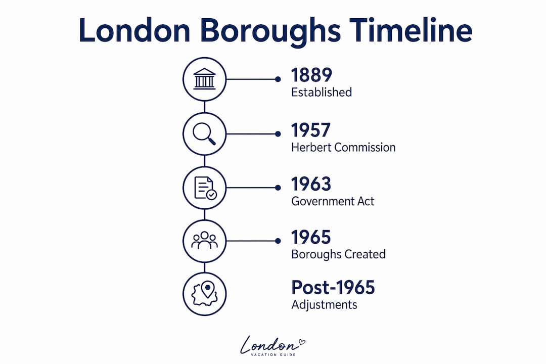
The Herbert Commission originally proposed 52 Greater London boroughs, a number that was subsequently reduced to 34 and finally to 32 following government intervention. Fewer boroughs meant larger units, which meant more mergers, which meant more naming disputes. Every merger required a decision about which community’s name would survive.
The government imposed specific rules to manage the chaos. Key constraints included:
- Borough names could not contain the word “and,” on the grounds that it implied two separate places rather than one unified authority.
- Names had to reflect genuine geographic or historic identity rather than invented or aspirational labels.
- Proposed names like “Riverside” were rejected for being too abstract, despite local support in some quarters.
- “New River” was similarly disallowed, as it referenced a single landmark rather than a community.
The “and” rule had one notable exception from the outset. Kensington and Chelsea was the only borough originally permitted to use “and” in its name, a concession to the strong identities of both communities. Subsequent boroughs that wished to adopt “and” in their names had to do so through separate legislation, which reflects how politically charged even punctuation became in this process.
The mergers that produced today’s boroughs often required genuine diplomatic skill. Newham was formed from the county boroughs of East Ham and West Ham, two communities with distinct working-class identities and long-standing local pride. Barnet was assembled from the municipal boroughs of Barnet, East Barnet, and Friern Barnet, along with the urban districts of Finchley, Chipping Barnet, and Potters Bar. In each case, the chosen name had to be acceptable to communities that had previously been rivals.
Pro Tip: If you want to understand why a particular borough has its name, look up the communities that were merged to create it. The chosen name almost always tells you which community had the most political leverage in 1963.
Local identity was preserved not just in borough names but in the names of districts within boroughs. Bermondsey, Peckham, and Nunhead all survived as neighbourhood names within the London Borough of Southwark, even though they ceased to be separate administrative units. This layering of old place names within new administrative structures is one of the most distinctive features of London’s geography.
How do inner and outer london boroughs differ?
The 32 London boroughs are divided into two formal categories: 12 Inner London boroughs and 20 Outer London boroughs. This distinction is not merely geographic. It was built into the 1965 structure for specific administrative reasons.
| Category | Boroughs | Key Characteristic |
|---|---|---|
| Inner London | 12 boroughs including Islington, Lambeth, Hackney | Higher population density, older housing stock, closer to the historic core |
| Outer London | 20 boroughs including Bromley, Havering, Hillingdon | Lower density, more suburban character, larger geographic area |
| City of London | Separate entity | Medieval governance, sui generis status, not a borough |
The most significant practical consequence of the Inner/Outer distinction was educational. Inner London boroughs were designated to maintain the Inner London Education Authority (ILEA), a body that managed schools across the inner core from 1965 until its abolition in 1990. The ILEA was controversial throughout its existence, praised for its progressive educational policies and criticised for its cost and management. Its abolition under the Education Reform Act 1988 transferred education responsibilities to individual Inner London boroughs, a change that reshaped local governance significantly.
The City of London sits entirely apart from this structure. The City retains separate, sui generis governance that has been maintained since the medieval era. It is not a borough, not Inner London, and not Outer London. Its governing body, the City of London Corporation, predates Parliament itself and operates under a constitution that has evolved over nearly a thousand years. The City covers just one square mile, houses fewer than 10,000 residents, but hosts one of the world’s largest financial centres. You can read more about its unique character in the City of London neighbourhood guide on London Vacation Guide.
Pro Tip: When visiting the City of London, look for the boundary markers at street level. Small metal dragons mark the points where the City’s jurisdiction begins, a visible reminder of its distinct medieval identity.
The Inner/Outer distinction also shapes how boroughs present themselves to visitors. Inner London boroughs such as Tower Hamlets, Southwark, and Camden contain the highest concentration of historical landmarks in London, from the Tower of London to Shakespeare’s Globe. Outer London boroughs like Richmond upon Thames and Greenwich offer a different kind of history: royal parks, riverside palaces, and the kind of open space that the inner city cannot provide.
Which boroughs hold royal status and why?
Three London boroughs carry the designation of Royal Borough, a title that reflects genuine historic connections to the monarchy rather than ceremonial invention. Kingston upon Thames, Kensington and Chelsea, and Greenwich each hold this status for distinct historical reasons.
- Kingston upon Thames was the site of Anglo-Saxon coronations. Seven Saxon kings were crowned at Kingston, including Athelstan in 925 AD, making it one of the oldest royal sites in England. The Coronation Stone, a large block of sandstone, still stands in the town centre as a physical link to that era.
- Kensington and Chelsea earned its royal designation through its long association with the monarchy. Kensington Palace has been a royal residence since William III purchased it in 1689, and it remains home to members of the Royal Family today. The borough also contains the Royal Hospital Chelsea, founded by Charles II in 1682.
- Greenwich received Royal Borough status in 2012, in recognition of its extraordinary royal heritage. The Old Royal Naval College, the Queen’s House, and the National Maritime Museum all stand within its boundaries. Greenwich was the birthplace of Henry VIII, Mary I, and Elizabeth I, a concentration of royal history unmatched by any other borough.
Royal Borough status carries real weight for local identity and tourism. Visitors who understand the London boroughs timeline can use these designations as a guide to where the deepest layers of royal history are concentrated. The Royal Parks of Greenwich and Richmond are among the finest examples of how royal patronage shaped the physical character of London’s outer boroughs.
Beyond the three Royal Boroughs, many other boroughs carry significant ceremonial and historical weight. The London Borough of Tower Hamlets contains the Tower of London, which has served as a royal palace, prison, and treasury since the eleventh century. The London Borough of Westminster, though not a Royal Borough in the formal sense, contains Buckingham Palace, the Houses of Parliament, and Westminster Abbey, making it arguably the most symbolically significant borough in the country.
How do borough boundaries reflect london’s layered history?
Borough names compress centuries of local history, reflecting Anglo-Saxon roots and evolving identities within a modern administrative framework. Reading a map of London’s boroughs is, in effect, reading a compressed historical record of the city’s development across more than a thousand years.
The Anglo-Saxon origins of many borough names are immediately apparent. Havering derives from a Saxon personal name. Barking and Dagenham both contain Old English elements. Lewisham comes from “Liofshema,” a Saxon term meaning the homestead of a man named Liof. These names survived the Norman Conquest, the Black Death, the Great Fire, the Industrial Revolution, and two world wars, and they survive still in the names of London’s local authorities.
| Borough | Name Origin | Historical Period |
|---|---|---|
| Havering | Saxon personal name “Haefer” | Anglo-Saxon |
| Lewisham | Old English “Liofshema” | Anglo-Saxon |
| Southwark | “Suthringa geweorche” (southern defensive work) | Anglo-Saxon/Norman |
| Greenwich | “Grene wic” (green village) | Anglo-Saxon |
| Bromley | “Brom leah” (bramble clearing) | Anglo-Saxon |
The mergers that created the boroughs also tell a story about London’s industrial and social geography. Newham, formed from East Ham and West Ham, reflects the docklands economy that once dominated east London. Hammersmith and Fulham preserves the names of two riverside communities whose histories are bound up with the Thames. Tower Hamlets, perhaps the most historically resonant name of all, references the hamlets that once fell under the jurisdiction of the Tower of London.
Boundary reviews since 1965 have adjusted borough lines only slightly, which indicates that the original structure achieved a reasonable balance between administrative practicality and community identity. The stability of the current layout is itself a historical statement: the 1965 reorganisation was thorough enough that it has not required fundamental revision in over sixty years.
Pro Tip: Explore borough boundaries on foot rather than by tube. Walking from Southwark into Lambeth, or from Hackney into Tower Hamlets, you cross invisible administrative lines that carry centuries of distinct local history. The character of the streets changes in ways that maps alone cannot convey.
Boroughs today serve as focal points for heritage tourism in ways their creators did not anticipate. The London Borough of Southwark markets itself around its medieval and Shakespearean heritage. Hackney has built a cultural identity around its Victorian terraces and twentieth-century immigrant communities. Each borough has become, in effect, a brand built on historical foundations laid long before 1965.
Key takeaways
The history of London boroughs is the story of how a fragmented medieval city was reorganised into 32 coherent local authorities in 1965, preserving centuries of place names and community identity within a modern governance structure.
| Point | Details |
|---|---|
| Created in 1965 | The 32 boroughs and Greater London were formally established on 1 April 1965 under the London Government Act 1963. |
| Replaced fragmented governance | Metropolitan boroughs, county boroughs, and urban districts were consolidated into a unified two-tier system. |
| Names carry deep history | Borough names reflect Anglo-Saxon, medieval, and modern identities, preserved through politically charged naming decisions. |
| Three Royal Boroughs exist | Kingston upon Thames, Kensington and Chelsea, and Greenwich hold royal status for distinct historic reasons. |
| City of London stands apart | The City retains medieval sui generis governance and is not classified as one of the 32 boroughs. |
Why borough history changes how you see london
I have spent years researching London’s urban history, and the borough naming process is one of the most genuinely surprising stories in British administrative history. Most people assume the boroughs were drawn up by civil servants with maps and rulers. The reality is far messier and far more interesting.
The fight over whether Kensington and Chelsea could keep its “and” tells you something important about how Londoners relate to place. These were not abstract bureaucratic decisions. They were arguments about identity, about which communities mattered, about whose history would be written into the official record. The fact that “Riverside” was rejected as a borough name because it was too vague reveals a genuine philosophy at work: London’s boroughs were meant to be rooted in real places with real histories, not invented labels.
For history students, the borough system is a masterclass in how administrative structures encode social and political values. The Inner/Outer distinction was not just geographic. It was a statement about which parts of London needed more intensive governance. The preservation of the City of London’s medieval constitution within a modern democratic framework is, frankly, extraordinary. No other major city in the world has anything quite like it.
For visitors, understanding borough history transforms the experience of moving through London. When you cross from Southwark into the City, you are crossing a boundary that has existed in some form since the eleventh century. When you walk through Kingston upon Thames and see the Coronation Stone, you are standing at a site that was politically significant before the Norman Conquest. That depth of history is available in almost every borough, if you know where to look.
The boroughs are not just administrative units. They are the most detailed historical map of London that exists.
— Matt
Explore london’s boroughs with london vacation guide
London Vacation Guide has built detailed neighbourhood guides covering the history, character, and visitor highlights of London’s most fascinating areas. Whether you are planning your first visit or returning to dig deeper into the city’s past, the first-time visitor guide offers borough-by-borough itineraries that connect historical context with practical travel advice. For those drawn to the riverside heritage of south-west London, the Richmond neighbourhood guide covers one of the capital’s most historically rich outer boroughs in detail. London Vacation Guide also covers dining and experiences within historic borough settings, including Borough Market Kitchen in Southwark, one of London’s oldest trading sites.
FAQ
When were the london boroughs created?
The 32 London boroughs were created on 1 April 1965 under the London Government Act 1963, replacing the earlier system of metropolitan boroughs and county boroughs.
How many london boroughs are there?
There are 32 London boroughs in total, divided into 12 Inner London and 20 Outer London boroughs. The City of London is a separate entity and is not counted among the 32.
Which boroughs are royal boroughs?
The three Royal Boroughs are Kingston upon Thames, Kensington and Chelsea, and Greenwich. Each holds royal status due to historic connections with the monarchy, from Saxon coronations to royal residences.
Why does the city of london have separate governance?
The City of London has maintained independent administration since the medieval era, operating under the City of London Corporation rather than the standard borough council structure. Its governance predates Parliament and has never been absorbed into the borough system.
What replaced the london boroughs before 1965?
Before 1965, London was governed through 28 metropolitan boroughs within the County of London, alongside county boroughs, municipal boroughs, and urban district councils in the surrounding areas. The London Government Act 1963 consolidated all of these into the current 32-borough structure.
Recommended
- London Neighbourhood Guides - Every Area Explained
- Best Food Markets in London: Borough, Broadway and Beyond - The London Journal | London Vacation Guide
- Best Areas to Stay in London: A Neighbourhood-by-Neighbourhood Guide - The London Journal | London Vacation Guide
- London Vacation Guide - Your Expert Guide to London